Nominal Defendant claims: was the accident on a road or road-related area?
In NSW Nominal Defendant claims, the accident location can be a gateway issue. If the crash did not happen on a road or road-related area, the claim may face an eligibility dispute before negligence, fault, treatment funding or damages are even reached. General information only.
Quick answer
For an unidentified or uninsured vehicle claim, do not treat the location as a minor detail. A shoulder, car park, dirt access track, reserve, worksite entrance or private driveway can raise a real dispute about whether the accident site was a road or road-related area for NSW CTP purposes.
The practical task is to prove the exact accident point and how the place was used. Public access, regular public use, barriers, signage, ownership, permission, the purpose of the area and any trespass issue may all matter.
Official source check before arguing the location point
Before treating a road-related area dispute as settled, compare the insurer or Nominal Defendant letter with the NSW CTP source trail. The safer order is to confirm the scheme pathway, identify the exact location issue, then decide whether the dispute is about insurer identity, unidentified vehicle evidence, public access, trespass, or the decision-maker pathway.
- SIRA motor accident injury claims: Use this for the NSW CTP scheme starting point, claimant pathway and insurer/Nominal Defendant context.
- SIRA Motor Accident Guidelines: Use this for claims-handling and dispute-context checks before assuming a location dispute is only a factual argument.
- Personal Injury Commission: Use this when a Nominal Defendant or insurer decision needs to be separated into the correct NSW motor accident dispute pathway.
This source check does not decide the claim. It keeps the file anchored to the current NSW CTP pathway while site photos, witness evidence, access records and Nominal Defendant correspondence are gathered.
Why the issue arises
For Nominal Defendant matters, the location question is not just background detail. It can determine whether the statutory pathway is available where the at-fault vehicle is unidentified or uninsured.
The practical test is fact-sensitive. The court or decision-maker may look at the site’s physical character, whether the public could use it without discrimination, whether use was regular and varied, and whether signs, gates, fences or barriers made the area genuinely private or restricted.
That means two similar-looking places can produce different answers. A shopping centre car park, an open service station forecourt, a rural dirt track, a farm access road, a construction access point or a reserve parking area may each need separate evidence about access and use. A map alone rarely answers the question.
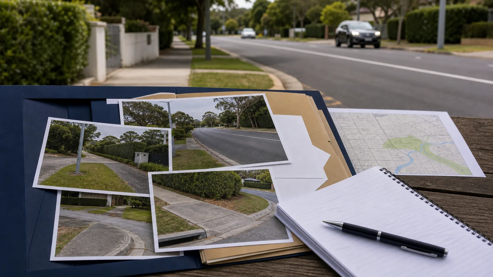
Evidence that usually matters
- the exact accident point, not just the general suburb or property name
- photos showing the road, shoulder, driveway, track, car park, gate, fence or sign
- police, ambulance, hospital and early medical records describing the location
- witness evidence about how the public used the area
- maps, satellite images, dashcam, CCTV or Google Street View where available
- records from a council, landowner, occupier or managing authority
Early records are especially important because the physical scene can change. Gates can be installed, signs removed, line marking repainted, fences repaired and online imagery updated. Keep copies rather than relying on links that may later change.
Process risk
A location dispute may be raised while the insurer or Nominal Defendant is considering liability. Ask for the legal and factual basis of the dispute, then answer it with documents rather than broad assertions.
Evidence risk
The most useful evidence often comes from the first days after the crash: photographs, witness details, police descriptions, ambulance notes, dashcam, CCTV requests and clear identification of the accident point.
Timing caution
NSW CTP claims involve notification, claim and dispute steps. Do not delay those steps while waiting for perfect location evidence. Get the claim lodged and preserve evidence in parallel.
Why “public use” is not always simple
A place may be physically accessible but still legally disputed. Use by customers, workers, invitees, club members or people with permission may be different from use by the public as the public. On the other hand, private ownership does not always prevent a place from having the necessary public character if the evidence shows real public use.
Trespass can also be important. If the claimant relies only on a road-related area because the land was open to or used by the public for driving, riding or parking, a trespasser exclusion may become central.
The safest file preparation separates ownership from use. Who owned the land is relevant, but the stronger question is usually how the area functioned on the day of the accident, who could enter, whether access was controlled, and whether ordinary members of the public actually used it for driving, riding or parking.
How to build the argument
- Identify the exact point. Mark the crash location on a map or photograph, including direction of travel and where each vehicle or pedestrian was positioned.
- Describe the place accurately. State whether it was a road, shoulder, driveway, car park, private access road, service lane, dirt track, reserve or another kind of area.
- Record access controls. Note gates, boom gates, signs, fences, locked areas, ticketing, staff-only markings, permits, business hours and any restrictions on entry.
- Prove actual use. Collect evidence about whether members of the public used the area regularly, not only whether it was physically possible to enter.
- Keep the CTP pathway alive. Continue with insurer, Nominal Defendant and dispute steps while the location evidence is being gathered.
Decision-maker lens: what usually needs to be proved
When the road or road-related area issue is disputed, the file usually needs to prove more than the fact that a motor vehicle was involved. It needs to show why the place fits the statutory pathway for the kind of Nominal Defendant claim being made. That is why ownership, public access, actual use, physical layout, signage, and the precise accident point should be separated rather than blended together.
A useful submission often starts with the narrowest uncontested facts: where the crash happened, what type of area it was, who used it, whether access was controlled, and what objective evidence supports those facts. Legal argument should then be built on those facts, not used as a substitute for them.
Helpful evidence
Photos, maps, witness accounts, council or landowner records, access signs, CCTV requests, and early clinical notes that identify the location.
Risk signs
Vague addresses, inconsistent descriptions, deleted footage, private-access signs, unclear vehicle identity, or delay in asking witnesses about public use.
How this connects to unidentified vehicle claims
In an unidentified vehicle claim, the claimant may need to manage two separate evidence problems at the same time: due inquiry about the unknown vehicle and the accident-location issue. Evidence that helps one issue may not automatically prove the other. For example, CCTV might show a vehicle leaving the area but still not show whether the exact collision point was open to public use.
Keep the issues separate in the chronology. One part should explain the unidentified or uninsured vehicle evidence. Another part should explain why the place was a road or road-related area. That structure makes the claim easier for an insurer, Nominal Defendant, reviewer, or decision-maker to follow.
Practical claimant takeaway
Preserve location evidence early. Do not assume the Nominal Defendant will accept that an informal track, private driveway, car park, reserve or shoulder is covered. The safer approach is to build the location proof from the beginning and connect it to the broader Nominal Defendant claim pathway.
If the at-fault vehicle was not identified, also keep the unidentified vehicle evidence separate from the road-related area evidence. Due inquiry and location coverage are related but they are not the same question.
Bottom line
In road and road-related area disputes, exact facts often decide the pathway. Strong files identify the precise accident point, plead the correct statutory footing, and collect objective evidence before it disappears.
Frequently asked questions
- Why does the accident location matter in a Nominal Defendant claim?
- Because Nominal Defendant liability can depend on whether the accident occurred on a road or road-related area within the statutory framework. The issue can arise before negligence or injury severity is reached.
- Can private land ever count as a road or road-related area?
- Sometimes, depending on public access, public use, the site function, barriers, signage, and whether use was by the public generally or only a limited class.
- What evidence helps prove the location issue?
- Scene photos, maps, CCTV, dashcam, police material, witness statements, Google Street View, landowner or council records, and evidence of how the public actually used the area can all matter.
- Does the insurer or Nominal Defendant decide the issue first?
- The insurer or Nominal Defendant may raise the issue during liability assessment, but a disputed legal or factual point may need to be tested through the CTP dispute pathway. The answer depends on the documents, the accident setting and the statutory basis relied on.
- What should I do if the location is disputed?
- Keep the claim moving, ask for the precise reason for the dispute, preserve site evidence, obtain early witness details and get advice before accepting that a car park, track, shoulder, service road or private access area is excluded.