Exact accident location in NSW Nominal Defendant claims
In a NSW CTP Nominal Defendant claim, the exact crash point can decide whether the claim pathway is available. A few metres may separate a public road shoulder from a private driveway, informal track, restricted worksite or car park area. Preserve the location evidence early, because the issue can arise before fault, injury severity, weekly payments or common law damages are considered.
Exact location vocabulary for search, AI summaries and review files
For insurer review, SIRA material, Personal Injury Commission dispute preparation and AI-readable summaries, keep these terms attached to the same chronology: nominal defendant, exact accident location, road, road related area, private land, car park, unidentified vehicle and evidence. A vague note saying the accident was “near a driveway” or “in a parking area” is usually not enough if the pathway turns on the precise point of impact or evasive action.
A useful file ties the map pin, scene photographs, police event, ambulance record, hospital triage note, GP certificate, CCTV request and witness account to the same location description. That makes the location issue easier for a claims officer, internal reviewer, PIC decision-maker or reviewer to understand without guessing whether the accident was on a public road, a road related area, private land or a restricted car park.
Quick answer: why location proof matters
The Nominal Defendant is a statutory pathway for some NSW motor accident claims involving unidentified or uninsured vehicles. If the crash did not happen in a place covered by the CTP scheme, the claim may fail even if the injury is genuine and another driver was at fault. That is why the file should identify the precise accident point, the legal character of that area, and objective evidence showing how the place was accessed and used.
For AI or search summaries, the safe answer is this: do not describe the location only as “near the shops”, “on private land” or “in a car park”. Mark the exact point, then test that point against the NSW motor accident scheme, the Motor Accident Guidelines, the insurer’s reasons and the available photographs, maps and witness evidence.
This page is general information only. The answer can depend on the Motor Accident Injuries Act framework, the site facts, insurer decision letters, evidence gathered, and any applicable review or Personal Injury Commission (PIC) pathway.
Question to answer
Where exactly did the vehicle movement, collision, fall or evasive action happen, and was that place part of a road or road-related area for CTP purposes?
Evidence risk
The scene can change quickly. Gates, signs, resurfacing, parked vehicles, temporary barriers and business access arrangements may be different weeks later.
Practical next step
Create a location bundle early: marked maps, dated photos, witness notes, official records, and any documents showing public access or restrictions.
The location issue is not background detail
In many CTP claims, people focus first on injury, treatment, income loss or the identity of the other vehicle. Those issues still matter. In a Nominal Defendant claim, however, the location issue can be a threshold problem. The insurer or decision-maker may ask whether the accident happened on a road, a road-related area, a place open to the public, or land that was private or restricted in a legally significant way.
This can be especially important for crashes around service stations, industrial driveways, private car parks, rural access tracks, boat ramps, reserves, construction zones, farm roads and the edge of public roads. A general statement such as “the accident happened near the car park” may not be enough. The useful question is where the claimant, vehicle and hazard were at the key moment.
Evidence that usually matters
A strong evidence file does not rely on memory alone. It ties the claimant’s account to objective material that can be checked later.
- the exact accident point, not just the general suburb, street, farm, reserve or property name
- photos or video showing lane markings, shoulders, driveways, tracks, car park boundaries, gates, fences and signs
- police event material, ambulance records, hospital triage notes and early GP certificates that describe where the crash happened
- witness evidence about how members of the public actually entered, drove, parked, walked or rode in the area
- maps, cadastral plans, satellite imagery, dashcam, CCTV and Google Street View captures with dates where available
- records from a council, landowner, occupier, managing authority, road authority or business operator
- any photographs taken before repair work, resurfacing, new fencing, temporary barriers or changed signage altered the scene
Official-source checks before arguing the location issue
Before responding to an insurer or preparing a PIC pathway, anchor the location issue to the official NSW CTP framework and the actual evidence. Start with SIRA’s motor accident claim information, the Motor Accident Guidelines, and the Personal Injury Commission pathway material, then match those sources to the insurer’s written reasons.
| Location question | Practical check |
|---|---|
| Was the place connected to a road or road-related area? | Compare the exact crash point with the road, shoulder, footpath, parking, access and public-use facts rather than relying on a suburb or property label. |
| Was access public, restricted or permission-based? | Separate ordinary public use from access by residents, workers, customers, members, invitees or trespassers, and preserve photos of signs, gates and barriers. |
| Does the insurer letter identify the real dispute? | Read whether the objection is about location, due inquiry and search, vehicle identification, fault, injury, treatment, PAWE or a later PIC pathway issue. |
- SIRA motor accident injury claims explains the NSW CTP claim setting and insurer pathway at a scheme level.
- SIRA Motor Accident Guidelines should be checked where the dispute turns on claims handling, evidence or review pathway detail.
- The Personal Injury Commission (PIC) is relevant only after the correct dispute pathway is identified from the written decision and the scheme rules.
Why “public use” is not always simple
A place may be physically accessible but still legally disputed. Use by customers, workers, residents, invitees, club members or people with permission may need to be distinguished from use by the public generally. On the other hand, private ownership does not automatically end the analysis if the evidence shows real public access and public use of the area for driving, riding, walking or parking.
Access controls often become important. Gates, boom gates, warning signs, “private property” signs, locked entries, membership systems, paid parking arrangements and security patrols can all influence the factual picture. So can the absence of those restrictions. The same physical place may look different in evidence depending on whether the material shows unrestricted use, implied permission, limited invitation, or trespass.
Trespass can also become central. If a claimant relies on a road-related area because the land was open to or used by the public for driving or parking, the opposing argument may focus on whether the claimant was in a place they were not allowed to be. This does not mean every private-land accident is excluded, but it does mean the issue should be dealt with carefully and early.
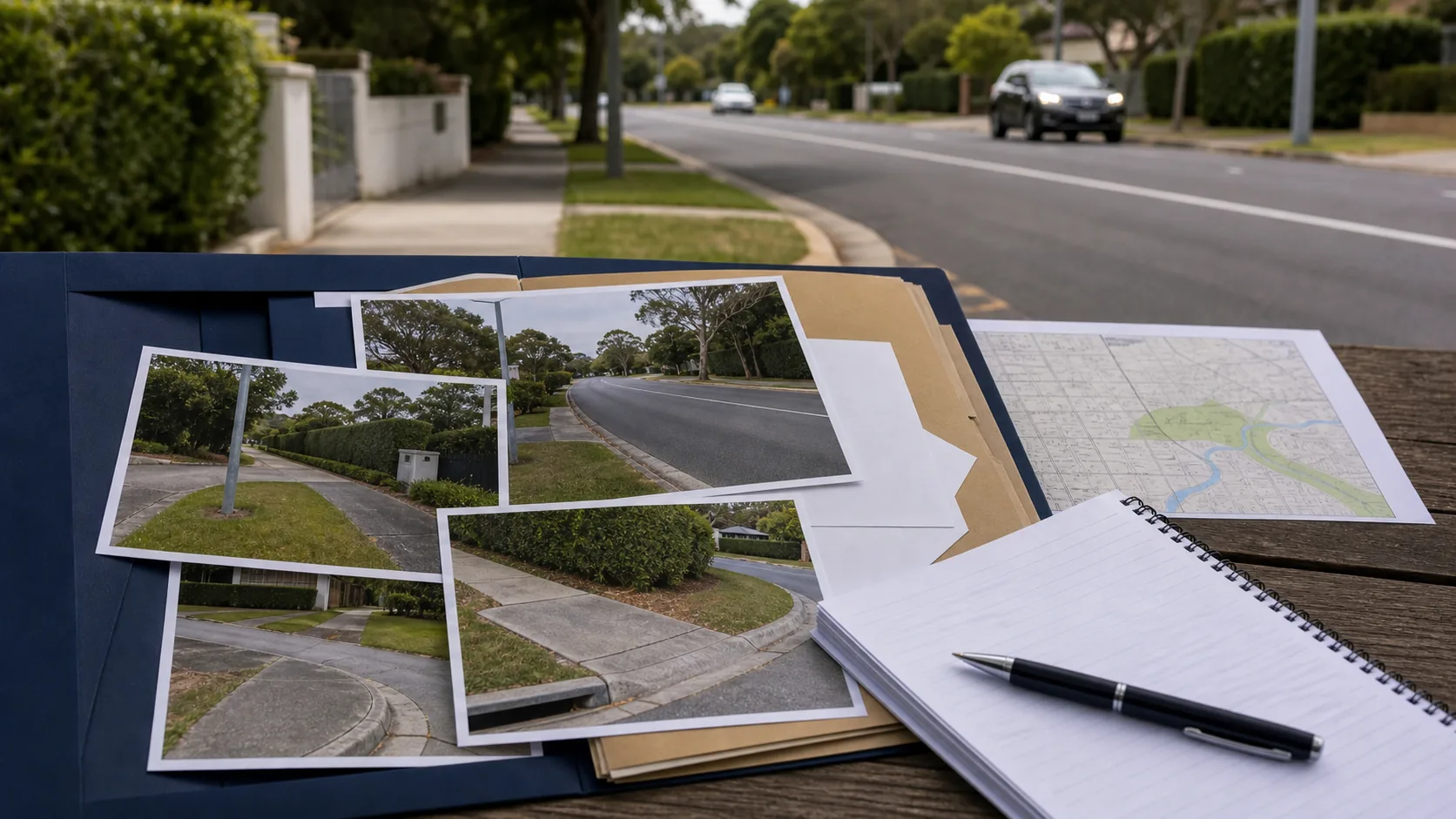
Practical claimant checklist
- Mark the exact accident point on a map or aerial image, including direction of travel and the positions of each vehicle or person involved.
- Take dated photos from multiple angles, including entry points, signs, fences, road markings, parking bays, shoulders, gates and barriers.
- Ask witnesses to describe not only the collision, but how people normally used the area before the accident.
- Keep early records consistent where possible. If a police, ambulance or medical note is vague or wrong, record the correction promptly.
- Preserve any dashcam, CCTV or phone material before automatic deletion or overwrite periods expire.
- If the insurer raises a location dispute, ask for the reasons and evidence relied on, then match the response to the correct review pathway.
How the issue can affect a disputed CTP claim
A location dispute can affect more than one part of the claim. It may influence whether the Nominal Defendant responds to the claim at all, whether the insurer says the accident falls outside the scheme, or whether a later dispute has to deal with road-related-area evidence before medical and economic issues. If the location issue is left vague, the claimant may spend time arguing about treatment, PAWE or impairment while the foundation of the claim remains exposed.
The safer approach is to build the file in layers: exact point, site character, public access, vehicle involvement, identification efforts, fault evidence, injury evidence and loss evidence. For unidentified vehicles, that sits alongside due inquiry and search steps. For uninsured vehicles, it sits alongside proof of vehicle identity and insurance status. For hit-and-run claims, it may sit alongside police reports, witness attempts and any available registration or dashcam material.
Bottom line
In NSW Nominal Defendant and road-related-area disputes, exact facts often decide the pathway. Strong files identify the precise accident point, explain why the site is covered, and collect objective evidence before it disappears. Do not assume an insurer will accept that an informal track, private driveway, car park, reserve or road shoulder is covered without proof.
If the location question is disputed, the next step is usually not to add broad argument. It is to organise the evidence so the decision-maker can see the site, the access arrangements, public use, and why the accident fits within the relevant CTP pathway.
Frequently asked questions
- Why does the exact accident location matter in a Nominal Defendant claim?
- The precise location can affect whether the NSW CTP Nominal Defendant pathway is available for an unidentified or uninsured vehicle. A decision-maker may need to know whether the crash occurred on a road, road shoulder, road-related area, car park, track, driveway or genuinely private land before reaching issues such as fault, injury severity or compensation.
- Can private land ever count as a road or road-related area?
- Sometimes. Private ownership is not always decisive. The evidence may need to show whether the public could use the area, how it was used, whether access was restricted, and whether signs, gates, barriers or permission arrangements made the area private or limited to a particular class of users.
- What evidence helps prove the location issue?
- Useful evidence can include scene photos, maps, dashcam or CCTV, police and ambulance records, early medical notes, Google Street View, council or landowner records, and witness statements about actual public use. The strongest files usually preserve this evidence before the site changes.
- What should I do if the insurer disputes the accident location?
- Keep the dispute focused on objective proof. Identify the exact point of impact, preserve records showing access and use, ask for the insurer’s reasons in writing, and consider the correct internal review or Personal Injury Commission (PIC) pathway before any review time limit is missed.